Jintotolo
| Jintotolo
| ||
|---|---|---|
 | ||
| Gewässer | Jintotolo-Kanal | |
| Inselgruppe | Visayas | |
| Geographische Lage | 11° 50′ 59″ N, 123° 7′ 41″ O | |
| ||
| Länge | 3,2 km | |
| Breite | 2,1 km | |
 | ||
Jintotolo, englisch Jintotolo Island[1], ist eine philippinische Insel im Norden des Jintotolo-Kanals, einer Meerenge zwischen der Sibuyan-See und der Visayas-See.
Geographie
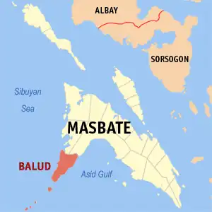
Die Insel liegt knapp 6 km vor der Südwestküste von Masbate. Im Westen von Jintotolo steht ein alter Leuchtturm (Jintotolo Island Lighthouse).[2]
Verwaltung
Jintotolo gehört zur Gemeinde Balud (Municipality of Balud) in der philippinischen Provinz Masbate.
Weblinks
Commons: Jintotolo – Sammlung von Bildern, Videos und Audiodateien
Einzelnachweise
- ↑ Jintotolo Island. In: geonames.org. Abgerufen am 23. Oktober 2022 (englisch).
- ↑ Faro de Isla Jintotolo (Jintotolo Island Lighthouse). In: lakwatsero.com. Abgerufen am 23. Oktober 2022 (englisch).