Lehota pod Vtáčnikom
| Lehota pod Vtáčnikom | |||
|---|---|---|---|
| Wappen | Karte | ||
 |
| ||
| Basisdaten | |||
| Staat: | |||
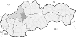
| Kraj: | Trenčiansky kraj | ||
| Okres: | Prievidza | ||
| Region: | Horná Nitra | ||
| Fläche: | 27,97 km²[1] | ||
| Einwohner: | 3697 (31. Dez. 2024)[2] | ||
| Bevölkerungsdichte: | 132,16 Einwohner je km² | ||
| Höhe: | 397 m n.m. | ||
| Postleitzahl: | 972 42 | ||
| Telefonvorwahl: | 0 46 | ||
| Geographische Lage: | 48° 42′ N, 18° 36′ O | ||
| Kfz-Kennzeichen (vergeben bis 31.12.2022): |
PD | ||
| Kód obce: | 514136 | ||
| Struktur | |||
| Gemeindeart: | Gemeinde | ||
| Gliederung Gemeindegebiet: | 2 Gemeindeteile | ||
| Verwaltung (Stand: Oktober 2022) | |||
| Bürgermeister: | Michal Ďureje | ||
| Adresse: | Obecný úrad Lehota pod Vtáčnikom Námestie SNP 33/1 97242 Lehota pod Vtáčnikom | ||
| Webpräsenz: | www.lehotapodvtacnikom.sk | ||
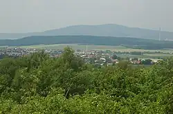
Lehota pod Vtáčnikom ist eine Gemeinde in der Slowakei.
Sie entstand 1960 durch den Zusammenschluss der Gemeinden Malá Lehota (deutsch Klein-Lehotta, ungarisch Kispapszabadi) und Veľká Lehota (deutsch Groß-Lehotta, ungarisch Istvánszabadja).
Bevölkerung
| Jahr | 1994 | 2004 | 2014 | 2024 |
|---|---|---|---|---|
| Anzahl der Personen | 3695 | 3791 | 3922 | 3697 |
| Unterschied | +2,59 % | +3,45 % | −5,73 % |
| Jahr | 2023 | 2024 |
|---|---|---|
| Anzahl der Personen | 3740 | 3697 |
| Unterschied | −1,14 % |
Weblinks
Commons: Lehota pod Vtáčnikom – Sammlung von Bildern, Videos und Audiodateien
Einzelnachweise
- ↑ Hustota obyvateľstva - obce [om7014rr_obc=AREAS_SK, v_om7014rr_ukaz=Rozloha (Štvorcový meter)]. Statistical Office of the Slovak Republic, 31. März 2025, abgerufen am 31. März 2025 (slowakisch).
- ↑ Počet obyvateľov podľa pohlavia - obce (ročne) [om7101rr_obce=AREAS_SK]. Statistical Office of the Slovak Republic, 31. März 2025, abgerufen am 31. März 2025 (slowakisch).
- ↑ a b Počet obyvateľov podľa pohlavia - obce (ročne) [om7101rr_obce=AREAS_SK]. Statistical Office of the Slovak Republic, 31. März 2025, abgerufen am 31. März 2025 (slowakisch).