Saint-Quentin-de-Caplong
| Saint-Quentin-de-Caplong | ||
|---|---|---|
.svg.png)
|
| |
| Staat | ||
| Region | Nouvelle-Aquitaine | |
| Département (Nr.) | Gironde (33) | |
| Arrondissement | Libourne | |
| Kanton | Le Réolais et Les Bastides | |
| Gemeindeverband | Pays Foyen | |
| Koordinaten | 44° 47′ N, 0° 8′ O | |
| Höhe | 18–111 m | |
| Fläche | 11,27 km² | |
| Einwohner | 256 (1. Januar 2022) | |
| Bevölkerungsdichte | 23 Einw./km² | |
| Postleitzahl | 33220 | |
| INSEE-Code | 33467 | |
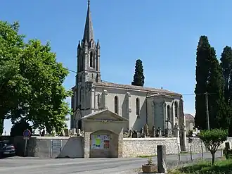 Kirche Saint-Quentin | ||
Saint-Quentin-de-Caplong ist eine französische Gemeinde mit 256 Einwohnern (1. Januar 2022) im Département Gironde in der Region Nouvelle-Aquitaine.
Geografie
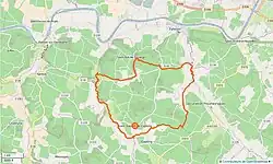
Saint-Quentin-de-Caplong liegt zwischen Libourne und Bergerac, nah dem Fluss Dordogne im Weinbaugebiet Sainte-Foy-Bordeaux.
Bevölkerungsentwicklung
| Jahr | 1962 | 1968 | 1975 | 1982 | 1990 | 1999 | 2006 | 2017 |
| Einwohner | 388 | 402 | 340 | 293 | 312 | 276 | 252 | 243 |
Sehenswürdigkeiten
- Kirche Saint-Quentin
Literatur
- Le Patrimoine des Communes de la Gironde. Flohic Éditions, Band 2, Paris 2001, ISBN 2-84234-125-2, S. 1458.
Weblinks
Commons: Saint-Quentin-de-Caplong – Sammlung von Bildern, Videos und Audiodateien